My biggest pet peeve is the posting of coordinates for a cache, when the poster has full-knowledge of the fact that the coords might be obscured by trees, buildings, or other natural and man-made structures. What's the point of cache hunting with a GPS unit if you can't get within at least 20 feet of a cache with your GPSr?!
This would just be a gripe post, if it weren't for 2 simple solutions. A: Don't place a cache here. Geocaching requires a GPS unit, and nobody likes to venture out to a cache site only to find that the coords are grossly inaccurate, thus decreasing the 20ft accuracy to 150ft or more. B: Use basic arithmetic! (my favorite) If you can use a GPSr, then you can probably use a calculator with a certain degree of ease.
It's simple. What you do is walk to a point where you CAN get a reading, and write that reading down. Walk around the cache outside of the GPS obscured area, writing down each individual reading you take. When you are done, average out the readings by adding the readings you wrote down together and dividing the sum by the number of readings you took. This way, you can heighten the accuracy of the cache location by using averages to move the resulting coordinates to an area inside the obscured cache location. Say that three times fast! Confused? I'd probably be confused too, so I've opted to break each step down visually (below) with text explanations for each step.
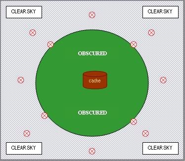
Here's a diagram of this method (explanation below):

The brown colored container in the middle of the above diagram is in an area obscured by tree cover (represented by the dark green circle). The bluish area outside of this area is clear sky, and accurate GPS readings can be taken anywhere in this clear sky area (represented by slanted blue lines). You can't take any accurate readings under the obscuring tree cover, but you can take as many as you like in the clear sky area, so that's exactly what you do (represented by red circles). Write down each individual reading, add them together and divide the sum by the number of readings you took. Here's an example:
6 READINGS
1. N 34 09.1301 W 118 49.4508
2. N 34 09.1314 W 118 49.4498
3. N 34 09.1303 W 118 49.4507
4. N 34 09.1304 W 118 49.4509
5. N 34 09.1295 W 118 49.4510
6. N 34 09.1302 W 118 49.4516
You don't need to add together the first two sets of each reading (11 22.3333), just the last four digits (unless during your averaging you actually change one of these values
 )
)So lets start by adding together the last four digits of the North readings (1301+1314+1303+1304+1295+1302 = 7819). Once we know the sum (7819), we can now divide it by the number of readings we took (6). (7819/6 = 1303) Now we know the most accurate North latitude reading, which would be N 34 09.1303, where we simply plug in the 1303 from the math we just did into the last four places of the North reading from readings 1-6. Now, repeat the exact same procedure for the West readings (4508+4498+4507+4509+4510+4516 = 27048). Now divide the sum (27048) by the number of readings we took (6). (27048/6 = 4508) Now we know the most accurate West latitude reading, which would be W 118 49.4508, where we simply plug in the 4508 from the math we just did into the last four places of the West reading from readings 1-6.
Take the North and West readings we just created using averages, and viola! You have a more accurate cache location irregardless of the obscuring tree cover: N 34 09.1303 W 118 49.4508. Rinse, repeat, and enjoy!


1 comment:
Hey international friends! Cool site! The customer support seems good and the dating service maybe endless. Maybe I will have a better keyword, searching for match maker since my keyword "instant" did not fit as intended.
Glad I found you! Keep on keepin on!
Post a Comment