Monday, April 25, 2005

How to Place a Cache in a Location with Obscured Sky, Peventing Accurate GPSr Readings

I visited a cache last Friday nearby on my way back from a client meeting in Los Angeles, and had everything I needed to find it. GPS coordinates, basic cache data, and the cache hint. Satisfactory? Sure, if the coordinates are accurate enough. Unfortunately, the owner of the cache likely whipped out his GPS receiver, took a quick reading, and promptly placed the cache. His coordinates were about 50 feet off from the mark, thanks to tall trees all around the cache site. Ouch. Preventable? You bet! Let's find out how to lessen the degree of cache GPS innacuracy with a little easy math.

My biggest pet peeve is the posting of coordinates for a cache, when the poster has full-knowledge of the fact that the coords might be obscured by trees, buildings, or other natural and man-made structures. What's the point of cache hunting with a GPS unit if you can't get within at least 20 feet of a cache with your GPSr?!

This would just be a gripe post, if it weren't for 2 simple solutions. A: Don't place a cache here. Geocaching requires a GPS unit, and nobody likes to venture out to a cache site only to find that the coords are grossly inaccurate, thus decreasing the 20ft accuracy to 150ft or more. B: Use basic arithmetic! (my favorite) If you can use a GPSr, then you can probably use a calculator with a certain degree of ease.

It's simple. What you do is walk to a point where you CAN get a reading, and write that reading down. Walk around the cache outside of the GPS obscured area, writing down each individual reading you take. When you are done, average out the readings by adding the readings you wrote down together and dividing the sum by the number of readings you took. This way, you can heighten the accuracy of the cache location by using averages to move the resulting coordinates to an area inside the obscured cache location. Say that three times fast! Confused? I'd probably be confused too, so I've opted to break each step down visually (below) with text explanations for each step.

Here's a diagram of this method (explanation below):
Image hosted by Photobucket.com

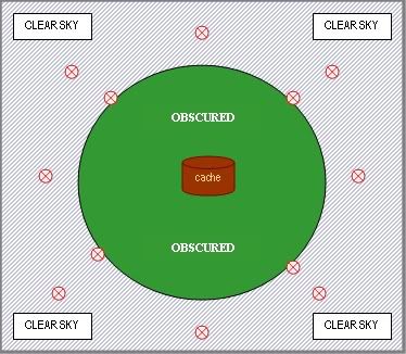
The brown colored container in the middle of the above diagram is in an area obscured by tree cover (represented by the dark green circle). The bluish area outside of this area is clear sky, and accurate GPS readings can be taken anywhere in this clear sky area (represented by slanted blue lines). You can't take any accurate readings under the obscuring tree cover, but you can take as many as you like in the clear sky area, so that's exactly what you do (represented by red circles). Write down each individual reading, add them together and divide the sum by the number of readings you took. Here's an example:

6 READINGS
1. N 34 09.1301 W 118 49.4508
2. N 34 09.1314 W 118 49.4498
3. N 34 09.1303 W 118 49.4507
4. N 34 09.1304 W 118 49.4509
5. N 34 09.1295 W 118 49.4510
6. N 34 09.1302 W 118 49.4516

You don't need to add together the first two sets of each reading (11 22.3333), just the last four digits (unless during your averaging you actually change one of these values )


So lets start by adding together the last four digits of the North readings (1301+1314+1303+1304+1295+1302 = 7819). Once we know the sum (7819), we can now divide it by the number of readings we took (6). (7819/6 = 1303) Now we know the most accurate North latitude reading, which would be N 34 09.1303, where we simply plug in the 1303 from the math we just did into the last four places of the North reading from readings 1-6. Now, repeat the exact same procedure for the West readings (4508+4498+4507+4509+4510+4516 = 27048). Now divide the sum (27048) by the number of readings we took (6). (27048/6 = 4508) Now we know the most accurate West latitude reading, which would be W 118 49.4508, where we simply plug in the 4508 from the math we just did into the last four places of the West reading from readings 1-6.

Take the North and West readings we just created using averages, and viola! You have a more accurate cache location irregardless of the obscuring tree cover: N 34 09.1303 W 118 49.4508. Rinse, repeat, and enjoy!

Saturday, April 16, 2005

Cache In, Trash Out (CITO)

Today was CITO day for the year of 2005. As you can see by the title, CITO means "Cache In, Trash Out." It's a reference given to the caching hobby, calling geocachers to visit all the caches they want, but in doing so to police the area for trash and other waste.

All over the world today, geocachers banded together in a unified collection of trash at some of the dirtiest cache sites. CITO events were established for groups of people to get together and collect garbage in support of our environment and community. While I couldn't visit a big site today, (the nearest was Hollywood) I was able to visit 2 of my local cache sites and pick up trash. By in large, the area I was at looked pretty clean, but after over an hour of walking and grabbing small/large pieces of trash I was shocked at the amount of stuff I'd collected. Here's a photo of the trash I grabbed today before it met the dumpster:
Image hosted by Photobucket.com

I'm not an environmentalist, but I do respect my home and like to see it clean. Today, in support of the CITO-day theme, I decided to pack out all this trash. Please think about bringing along a big trash bag the next time you decide to go organized geocaching. Don't forget to recycle your glass and plastics either!

Image hosted by Photobucket.com

Thursday, April 14, 2005

Benchmark Hunting

Geocaching is clearly the cat's meow when it comes to locating things with your GPS unit, but on the other side of GPS treasure hunts is Benchmark hunting. Benchmarks are markers of various types placed by the National Geodetic Survey teams over the past 200 years or so. More and more benchmarks are being placed and logged by other organizations (both military and private), which opens up an entirely new facet of GPS treasure hunting.

Geocaching.com allows users to log Benchmarks in addition to geocaches, so I thought I'd go ahead and explore it a bit. Turns out it can be quite rewarding if you want to just enjoy the thrill of the hunt and/or there aren't all that many caches in your area. I nabbed my first one about 3 days ago, and today on a short drive from Los Angeles County to Ventura, I grabbed 9 more.

Here's a sample of what a typical geodetical survey disk might look like:

Website Ticker

I must note that Blogger.com does give us users some pretty fancy access for free. Becuase I can tinker with the raw HTML code on this site, I've been able to add links and graphics that I preferred over the stock offerings that Blogger offered. Today I added an HTML ticker and stats tracker so I can see how many people are visiting my site and from where.

Neato beano!

Wednesday, April 13, 2005

New Micro's Arrived!

Today my new Pill Fob micros arrived UPS. I grabbed six of these plastic high-impact nitro pill cases off of Amazon at a $1.69 each (cheap!) here: EZY Dose Deluxe Nitro Pill Fob's - $1.69

I plan on sprucing up these containers with area-specific camouflage when it's time to place a few, and their unique design could make it pretty fun. Here's a shot of them with a nickel (for size comparison). Note the red rubber o-ring that seals out moisture: Image hosted by Photobucket.com

There's other Pill Fob's out there, even some specific to geocaching like the one in this picture:
Image hosted by Photobucket.com

Those metal pill FOB's are great, especially with the GEOCACHE markings emblazoned on the front. The only drawback of these containers is price. This particular model is being sold at over $4.50 a piece, not to mention that these colors don't exactly blend in well with the environment.

Monday, April 11, 2005

New Cache Containers Arrived!

Today the 5 Army Decon containers I ordered from www.armysurpluswarehouse.com arrived, and boy did I get a good deal. Under $10 for these 5! I've already taken the liberty of preparing them for placement as geocaches, with foreign currency, polished rocks, airline memorabilia, and some other small odds and ends.

Thanks to my labelmaker, I'm able to put a clear tag on the inside cap to alert unaware muggles. What do you think? Maybe someday I'll camo them a bit, but being Army issue they are naturally not light reflecting and that's good enough when mixed with the OD green color.
Image hosted by Photobucket.com

Respect for Nature

I'm no left-winger, trust me. I've never participated in a tree-hugging event, or a stand in for nature either. But when a fellow geocacher recently drew attention to test in a cache I'd hidden about dangerous insects such as spiders being "nasty," I took notice.

Geocaches don't sit on street corners in plain sight, or they'd be muggled in no time. Spiders, snakes, and other critters don't do that either or they'd likely be eaten up by winged predators. For these reasons, we usually hide geocaches is places less easily located--places that these insects and critters tend to make home. Either way, my geocaching pal was right. Just because these outdoor critters can cause harm to humans, they should not be feared.

Let's face it, for most geocachers the hobby is just another excuse to get out of our cars and onto our feet. Exploration! Usually, outdoorsmen and women tend to respect nature and mutual coexistence of all creatures, but it seems that too often people are frightful of multi-legged bugs and such because of the minor pain they can cause us when disturbed. This fear has created a culture of "destroy or be destroyed" and the nature around us is suffering. I ask, where will we take our children to see the way Earth was before mass overpopulation? What hills and forests will we hike?

The answer is in complete mutual respect. When you reach into a dark hole looking for a geocache, don't get angry with the critter that may get frightened and try to defend itself. After all, they were there first!

Friday, April 08, 2005

First Cache Stashed

Here's a link to the first cache I ever stashed away: Suburban Hills of TO


After 17 finds, I've become pretty well in-tune with the caching hobby and decided a few days ago to hunt down a great spot and place my first cache. I lifted an empty altoids container off of my mother-in-law and colored it black inside and out. Out here in Thousand Oaks, there is an abundance of rolling hills, and I was hoping to find a location that was not difficult to get to and still had a view. Luck shined upon me as I quickly located an excellent spot for my first cache, nicely situated in hilly suburbia on public land! (see the link above)

Thursday, April 07, 2005

The Equipment

Because I work in Real Estate, my PDA is my lifeline. We're attached at the hip. When the geocaching bug bit me last month, I decided to explore adding GPSr functionality to the PDA vs. purchasing a dedicated unit, and I'm glad I did. After a couple of bucks spent on a decent Bluetooth GPSr unit and some Pocket PC GPS software, I was up and running--paperless!

Here's a photo of my PDA and equipment:
Image hosted by Photobucket.com

I bought a Dell Axim X30 (mid-range, which is the 312mhz), and the black leather case on the left came with it. I usually use this case for light businessuse because it clips easily to my belt. The hard aluminum case in the foreground cost about $5 on eBay, and I make sure that the PDA is inside this when I step out of the car to look for caches. The small black device in the middle-back with the blue light in the center is my Holux GR-230 Bluetooth GPS receiver. On the far right is my Axim PDA in it's office cradle.

As far as software goes, I use 4 primary utilities/programs, all to which I have provided links for in the far right of this screen:
1. Mapopolis (incredible turn-by-turn navigation system) Cost me about $100.
2. GPXToMaplet (PC utility that converts .gpx files for use in Mapopolis) Freeware.
3. BeeLineGPS (Great for sensitive caching, once you leave the car) Cost me about $30.
4. GPXSonar (.gpx utility that allows you to carry cache details with you on your PPC PDA-I won't leave home without it) Freeware.

True, my configuration is a bit on the expensive side, and thus won't be the perfect fit for everyone. However, if you own or plan to own a PDA with bluetooth functionality and you'd like to use it for GPS driving or geocaching, this is the best configuration I've found (after testing quite a few).

Happy caching!

What's with the nickname acPilot?

It's actually pretty simple. Over the past 5-6 years, I have gone by many nicknames such as Casper, Risky, etc. When I registered with Geocaching.com, I wanted to start fresh with a new nickname which identified one of my largest interests--commercial aviation.

Still confused? Yeah, I'm getting there myself.. but let's push on. Being a huge commercial aviation enthusiast, I have pictures and displays of various aircraft all over my offices. I'm a complete nut. When I'm not caching, I take part in another hobby called "Aircraft Spotting". Essentially, I camp out in a comfortable spot nearby a large airport and watch the aircraft (and sometimes log the aircraft registration numbers). I've never been able to explore the chance of being a pilot, so I took the next best thing: simulation.

While time is extraordinarily limited these days, I fill this empty aviation hole with flight simulation on my PC at home. Microsoft Flight Simulator makes a very realistic simulation platform for "armchair pilots" such as myself, to have a good time and satisfy our interests. Armchair pilot = acPilot, and that's my nickname.

I probably could have simplified this into 2 sentences, but then that would be a REALLY boring blog now, wouldn't it? :)

Wednesday, April 06, 2005

Introduction

I've always enjoyed the concept of a journal, but I guess I always get bored after about a week or two, so this should be an interesting experiment.

This blog was started around one of my favorite hobbies: the art of geocaching. Never heard of it? Don't feel bad, I hadn't either until I stumbled across it on the internet. Now, a mere month after discovery, I own a wireless Bluetooth GPSr unit which works with my Dell Axim X30 PDA to make an efficient geocaching GPS unit. I love this little PDA, and I couldn't live without it, but that's another story altogether.

Rather than reinvent the wheel describing geocaching in it's entirety, I'll just post the link to the headquarters for geocaching all around the world: http://www.geocaching.com

Just a few days ago I was hunting for a "geocache calling card", something that can be used as a marker for caches I've visited. After a brief call with the local coin shop, I dropped by and picked up a huge bag of the old Mexican Pesos (you know, the ones that are worth 1000th of the current Peso, which coincidentally is only .10 cents to the US dollar). They are large and unique enough for my interests, so I think I'll be spending the next few weeks cleaning them up for use! Yay.

The Beginning!

What's all this talk about Blogs? I'd been asking this question over and over for at least a year, so I figured no better way to find out then actually participating in my own. Who knows? Maybe someday some college student looking for a quote will cite a half-witted comment of my own in their research paper.